Unquiet skies: clashes between weather and humanity
Frankenstorm still has East Coast in shambles and struggling for normalcy
By RILEY WILSON
It wouldn’t stop groaning.
The moans echoed through the halls with each blow. Surrounded by flickering flames in tiny glass jars, we waited. Rainwater seeped through the cracks in our windows and under our door. Darkness consumed much of the house, aside from our little glowing living room.
We waited for the walloping to end. We waited for the groaning to cease.
After a full night of beatings by the wind, our house slipped into silence. We, of course, thought it was over, and so we waited. We waited for the house to once again be illuminated by a returning power supply and to be warmed by a heating system eager to get back to work.
My family, in Boyds, Md., waited for five days. Unfortunately, our situation was preferable when compared to what the rest of the East Coast dealt with and still deals with today.
“It’s certainly past the modern historical record when…a hurricane made landfall in an area of a highly populated Northeast corridor where it’s done as much damage as it has,” Christopher Strong, a warning coordination meteorologist at the National Oceanic and Atmospheric Administration center for Baltimore and Washington D.C., said.
“It was an exceptional storm for the mid-Atlantic and for the Northeast,” Strong said. Strong, as a warning coordination meteorologist at NOAA, was tasked with overseeing the overnight shifts from 11 p.m. to 9 or 10 a.m. as the storm moved through.
“At least in the modern historical record since the 1900s, [the storm had a] really an impressive area of impact on the highest populated area of the United States,” Strong said.
America is only now beginning to really recover from what many dubbed the Frankenstorm, a word-play stemming from the novel “Frankenstein” by 19th century writer Mary Shelley.
The three components combining to form the monstrous storm “really were the hurricane, the high pressure that blocked [the hurricane] and caused it to track the way it did and then the cold front and the cold air moving down from the continent,” Strong said.
“When the hurricane got over the colder water off the mid-Atlantic, [the cold] really started shutting down the hurricane and really [the hurricane] became more like a winter storm,” Strong said. A hurricane is sustained by warm, humid air over tropical waters and, on the track it was on, Sandy lost that fuel, Strong said.
“What it was able to replace that with is what winter storms are fueled off of and that’s temperature contrast,” Strong said. “All that warm, humid air associated with a hurricane encountering cold air moving at it from the West [created] quite a temperature contrast.”
“That temperature contrast really allowed the storm to continue to maintain itself as it went well inland,” Strong said.
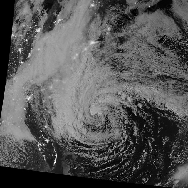
It's a storm that never slept. Above is a satellite view of Hurricane Sandy at night hitting the East Coast, image by NASA's Goddard Space Center.
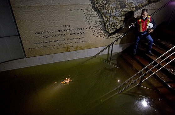
Joseph Leader, Metropolitan Transportation Authority Vice President, looks out to the waters flooding the South Ferry 1 train station in New York City. Photo by Craig Ruttle, courtesy of The Associated Press.